One of my goals is to have my students CREATE technology instead of simply CONSUMING it.
My class followed the Syrian refugee crisis quite closely. On Mondays my students’ interest was always piqued to see if it would make it on Flocabulary’s Week in Rap. They read about it on age appropriate Newsela (lexiles can be adjusted with a simple click of the button!) and of course my own eyes were peeled while perusing various social media sites for usable material.
One of the units I teach in Individuals & Societies is called Culture and Identity, and a part of this unit includes various mapping skills. This includes: using scale, latitude and longitude, reading a legend, cardinal and ordinal direction, etc. To hone in on the skills they were developing, I created a quick lesson on using Google Maps so that students could create their own maps. First, they got a feel for it while practicing on a map I made. For their own maps, I left the mapping up to them; it only needed to involve the Syrian conflict.
Here is a copy/paste of the learning activity.
Mapping the Refugee Crisis: Learning Activity
As we look deeper at the Syrian refugee crisis, it is time to apply our geography skills to what is happening in our world. You are now a geographer, so what can you do with your new skills.
- Practice
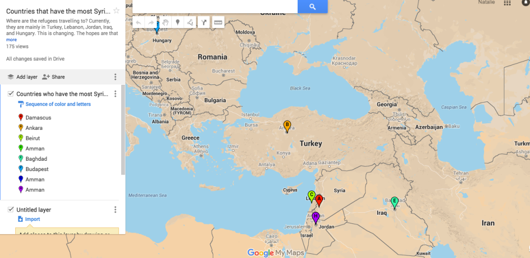
This Google Map represents the countries that have accepted the most Syrian refugees over the past few years. Note: It does not reflect the most current wave of refugees that are flooding into Europe. It also “pins” the capitals of these countries, and not where the refugee camps are located.
Question: Can you figure out the approximate distance from Damascus, Syria to the following locations? How about the cardinal or ordinal direction? Give it a try! You will need to use the ruler tool. **I have turned on the editing tool for this. Please do not add pins or move things!
| Location | Distance in Kilometres | Cardinal/Ordinal Direction |
| Ankara, Turkey | ||
| Beirut, Lebanon | ||
| Amman, Jordan | ||
| Baghdad, Iraq | ||
| Budapest, Hungary |
- Your Turn!
Think that you can design your very own Google Map that maps the refugee crisis? No need to map the same countries that were done in the practice round, as that has already been done. What could you map? Here are some ideas. Choose one, or come up with your own.
-Where do the refugees hope to go (Germany, Austria, United Kingdom, France, Italy, Greece, Sweden)
-Which countries donate the most money (United Kingdom, Germany, Norway)
-Wealthy Asian nations that could potentially take refugees (Russia, Japan, Singapore, South Korea)
-Time based on travelling by car, foot, boat, etc.
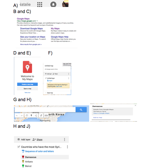
How to use Google Maps (screenshots are below)
- A) Make sure that you are signed into your google account
- B) Search “Google Maps”
- C) Choose “My Maps”
- D) Before “Creating a New Map” please “Take a Tour”
- E) “Create a New Map”
- F) Give your map a title based on what you are mapping
- G) Use the search bar to search locations this will bring you to the location you are looking for. Choose “Add to Map” if you want to drop that pin.
- H) Start dropping pins! This will save as a layer on your map
- I) Create a table like the table that was used in your practice round. You can do this directly on this document. This will be your question(s) for a classmate to follow. The questions you create are completely up to you!
- J) Save the link to your map and add the link to your questions/table
Enjoy being a geographer.